Olympic National Park


Located in the north-west of Washington State, Olympic National Park is renowned for the diversity of its ecosystems. Glacier-clad peaks interspersed with extensive alpine meadows are surrounded by an extensive old growth forest, among which is the best example of intact and protected temperate rainforest in the Pacific Northwest. Eleven major river systems drain the Olympic mountains, offering some of the best habitat for anadromous fish species in the country. The park also includes 100 km of wilderness coastline, the longest undeveloped coast in the contiguous United States, and is rich in native and endemic animal and plant species, including critical populations of the endangered northern spotted owl, marbled murrelet and bull trout.
Copyright © 1992 - 2006 UNESCO/World Heritage Centre. All rights reserved.


http://www.desiringgod.org/media/images/blog/1143_olympic_national_park.jpg


http://georgewashingtoninn.files.wordpress.com/2009/04/olympic_national_park_wildlife1.jpg


Nanda Devi and Valley of Flowers National Parks


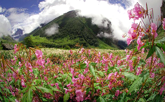
These are some of the most spectacular wilderness areas in the Himalayas. Dominated by the peak of Nanda Devi, which rises to over 7,800 m, Nanda Devi National Park has remained more or less intact because of its inaccessibility. It is the habitat of several endangered mammals, especially the snow leopard, Himalayan musk deer and bharal. The Valley of Flowers National Park is renowned for its meadows of endemic alpine flowers and outstanding natural beauty, and is also home to rare and endangered animals, including the Asiatic black bear, snow leopard, brown bear and blue sheep. Together they encompass a unique transition zone between the mountain ranges of the Zanskar and Great Himalaya, praised by mountaineers and botanists for over a century and in Hindu mythology for much longer.


Nandadevi National Park

Dwelling for endangered species of mammals such as bharal, snow leopard and the Himalayan musk deer, Nandadevi National Park is the least exploited park because of its inaccessibility. This Park is dominated by the Nandadevi peak (the second largest peak in India) that stands regally to a height of 7,800m. Hindus visit this place once in twelve years to worship the Trishul that is placed here.
http://mw2.google.com/mw-panoramio/photos/medium/5744640.jpg
Nandadevi National Park is located in the greater Himalayan ranges of the Chamoli district within the Gharwal division in the State of Uttaranchal. Entrance to the Park is from the Lata village, 23 km from Joshimath. The west side of this park is unreachable because of a ravine and the other three sides are covered by the mountain peaks.


http://media-cdn.tripadvisor.com/media/photo-s/01/23/4e/22/dehradun.jpg

http://static.guim.co.uk/Guardian/travel/gallery/2007/aug/14/india/flowers1-9311.jpg

Traverse of the Bonds


This NH hiking classic takes you over the most remote 4,000 footers in the White Mountains. Above treeline ridge walking nestled in the geographic center of the Pemi Wilderness. Easiest to do the traverse north to south to end with miles of flat railroad grade (bonus points for running this part). Obligatory Bondcliff shot at left.


Franconia Ridge Traverse


Many consider this the best day hike in the Northeast: a counterclockwise loop from Franconia Notch that ascends Little Haystack and traverses the Franconia ridge over Mt. Lincoln and 5,260ft Mt. Lafayette. The above-treeline Franconia Ridge section of the hike is one of the most exciting stretches of trail in the White Mountains, with full-frontal views of the Notch and the Kinsmans on one side and untainted views dropping into the gulf of the Pemigewasset Wilderness on the other. Do this hike (and prepare to see "a few people" up there).

http://www.dskendall.com/images/nh_lincoln.jpg

http://www.summitpost.org/images/original/19091.jpg

http://fatmanofthemountains.files.wordpress.com/2009/08/franconia-ridge.jpg

http://applianceguru.com/hello/201/976/1024/Franconia%20Ridge%2010262004%20006.jpg


http://applianceguru.com/hello/201/976/1024/Franconia%20Ridge%2010262004%20012.jpg


Tuckerman Ravine, Mt. Washington


Scenic bowl is one of the top hikes in the White Mountains, but even better skiing.

http://www.yockim.com/Highpoints/NewHampshire/MtWash2.jpg

http://www.skimountaineer.com/CascadeSki/Washington/MtWashingtonBigLake.jpg

http://thirdgradetrip.files.wordpress.com/2007/11/mt-washington-1.jpg

http://hauntedsandiego.com/wp/wp-content/uploads/2008/04/mt-washington.jpg

http://www.thermalseminars.com/Mt%20Washington.jpg

http://www.saugus.net/Photos/images/mount_mt_washington_hotel.jpg

http://www.pacificomm.net/utility/2008/BigLakeAndMetoliusAugust/original/Mt%20Washington.jpg

http://www.thesurf.us/temp/Mt%20Washington%20Bikes.jpg


Chicago Basin: Mt. Eolus


Mt. Eolus, the highest peak in the Weminuche Wilderness, is a tough climb that shouldn't be underestimated. On the approach, you must cross a narrow, exposed section called the Catwalk. Then, once across the ridge, the final climb is an interesting puzzle of routefinding among grassy ledges and rock blocks. The summit is broad and flat, and the views from here are the best in the entire area. If I were to climb one peak from the Chicago Basin, this would be it.

http://www.dskendall.com/images/co_eolus.jpg

http://freemanentropy.com/images/ChicagoBasin/ChicagoBasinCoverPhoto.jpg

The image “http://www.summitpost.org/images/medium/85142.jpg” cannot be displayed, because it contains errors.

http://www.powdermag.com/features/news/mt-eolus-line.jpg

http://img1.photographersdirect.com/img/11131/wm/pd1130536.jpg

http://home.att.net/~statcy.bender/photos/Eolus_frm_Windom.jpg

http://img1.photographersdirect.com/img/11131/wm/pd2488023.jpg

http://www.geoffmartindale.com/files/dsc01146-3.jpg

http://thomascrawfordphotography.com/wp-content/uploads/2008075d_16280.jpg

http://www.summitpost.org/images/original/70067.jpg


Chicago Basin: Sunlight Peak and Windom Peak


The summit block. After taking the Silverton train, backpacking in to the idyllic Chicago Basin, and climbing through tough terrain to above the 14,000 foot mark, you face what you knew you would have to face all along, and it's mentally not any easier. The famous summit block on Sunlight requires an awkward "leap of faith" move across a gap to a tiny perch of dizzying exposure. While some may have done headstands here in the past, I only managed to hug the rock for a moment before willing myself down. Windom, definitely not as epic as Sunlight, is a tough boulder-hopping climb with perfect views to add on after Sunlight. The remoteness of these peaks and views into the heart of the jagged Weminuche Wilderness (the largest in Colorado) make this a top 14er experience in Colorado. Not to be missed; also see my thoughts on Mt. Eolus.

http://home.att.net/~statcy.bender/photos/Sunlight_n_Windom.jpg

http://www.distantpeak.com/cms/files/DSCN1642.JPG

http://freemanentropy.com/images/ChicagoBasin/SunlightWindomByErinBurr.jpg

http://www.widerange.org/images/large/needlesLoop-windomSunrise.jpg

http://www.summitpost.org/images/medium/85142.jpg

http://img1.photographersdirect.com/img/11131/wm/pd1130529.jpg

http://img1.photographersdirect.com/img/11131/wm/pd2374850.jpg

http://www.gb4mfg.com/mtn/trip_reports/Win-Sun-Jup_070207/2007_0702_chi_basin0052.JPG

http://farm1.static.flickr.com/1/1173243_40f6e7744b.jpg

Crestone Peak and Crestone Needle


The awe-inspiring Crestones tower above the surrounding Sangres and exude a palpable sense of adventure. The standard routes up these peaks require considerable scrambling, with the Crestone Needle the tougher. Routefinding is essential, especially on the Needle with its couloir-hopping standard route. Wrong ways here quickly become class 5. The summits are both fully panoramic with a sense of extreme airiness and excellent views of the Great Sand Dunes off to the south. A hard day hike from South Colony Lake, over Broken Hand Pass, and up and down the south sides of both peaks. Traversing the ridge between the two peaks is a more difficult option.

http://www.dskendall.com/images/co_crestones.jpg

http://cs.samford.edu/steve/newsletter/CO%20climbing%2007/6c-04%20Crestone%20Needle%20and%20Humboldt%20from%20Crestone%20Peak%27s%20sub-peak.jpg

http://www.rockymountainrescue.org/photos/Crestone700.jpg

http://www.cloudhiking.com/images/peak.JPG

http://ndskier.com/images/PicturesPage/43b_crestone%20needle.JPG

http://sangres.com/cimages/features/panoramas04/crestone02big.jpg

http://tcs.net/michaels_blog/images/IMG_4181.JPG

http://img1.photographersdirect.com/img/11131/wm/pd1129161.jpg

http://www.justhiking.com/hikes/2005/06-18crep/crep02.jpg

http://www.summitpost.org/images/medium/392757.JPG


Mt. Massive


Yes, it is massive. Most above 14,000 acreage of any mountain in Colorado. Took the standard route starting on the Colorado Trail before an often gradual ascent through wide alpine meadows to the summit ridge. Long thought to be the highest 14er in Colorado before net-door neighbor Elbert took that crown.

http://www.dskendall.com/images/co_mt_massive.jpg

http://www.amazingcolorado.com/mount-massive1.jpg

http://www.jackieandalan.com/images/elbertmassive.jpg

http://farm1.static.flickr.com/188/457211263_a7ee4abda4.jpg?v=0

http://www.samoht.com/weblog_img/tl_mt_massive.jpg

http://photos1.meetupstatic.com/photos/event/1/9/5/b/highres_9546491.jpeg